Land use/land cover (LULC) or groundcover data can play a variety of roles in designing wireless communication systems. It can be used to improve predictions of signal attenuation and other radio propagation effects and to assist in siting of cellular base stations and other wireless system transmitters. It can also be utilized when projecting trends in PCS/cellular phone call traffic, particularly outside of dense urban areas. A new approach to classifying urban areas is proposed.
Wireless communication is one of the most rapidly growing industries worldwide. Whether it's the ubiquitous cellular phones and pagers, or more traditional systems such as radio and television broadcasting, wireless communication has become a vital component of fundamental societal infrastructures which rivals in importance traditional transportation, electric and water systems. Many developing countries have put the deployment of two-way communication systems at a higher priority than other traditional infrastructures.
With literally billions of dollars being spent annually on building wireless communication systems, there is significant incentive to devise engineering tools that can accurately and efficiently design and plan such systems. There are currently a number of software tools on the market intended for just that purpose. Considering that a single cell system base station can cost more than a half a million dollars, an efficient system design which eliminates just one such station can easily justify the expense of the design tool and the effort using it. As the wireless system grows to meet increasing and changing demands for service, the design tool is again a valuable asset in planning optimum modifications to the system to accommodate growth.
Of fundamental importance to the wireless system design tool is the ability to accurately predict the strength of radio signals from the various transmitters in the system. The mathematical algorithms used for prediction are generally known as propagation models.
Traditionally, propagation models have relied on terrain elevation data as the sole environment parameter on which to base predictions. Substantial effort has been invested over the past several years in developing accurate DTEMs (digital terrain elevation models) for various parts of the world. While terrain has a profound effect on the propagation of radio signals (especially at higher frequencies), more localized features of the environment such as trees and structures (buildings, houses, etc.) can also have a substantial impact on propagation. One widely used propagation model, developed in the 1960s, is defined in terms of land use categories [1]. An important trend in wireless system architecture is to use smaller cell coverage areas (so-called microcells) and much higher radio frequencies where significantly greater transmission bandwidth is available. These broadband point-to-multipoint systems are used for carrying video, voice and data signals. For such short-range microcell system architectures where the coverage radius of the transmitter may range from 0.5 to 5 kilometers, the terrain can often be regarded as locally flat. Under such conditions, signal propagation is dominated by local obstructions rather than by terrain, making the description and accurate classification of land use/land cover data of primary importance.
The goal of this paper is to discuss the application of land use/land cover (or groundcover) data to the wireless system design process. Section 2 provides background information explaining the physical mechanisms behind the impact of land cover features on signal propagation. Based on the physical mechanisms at work, Section 3 suggests a quantitative way to classify urban groundcover data to improve its value in the propagation modeling process. Section 4 discusses how groundcover data can be used to predict the dynamic demand for cellular service and other types of wireless system traffic. Section 5 presents two wireless system coverage studies illustrating the impact of groundcover data on signal strength. Finally, Section 6 presents some useful conclusions concerning the appropriate number of land use classification categories and the acceptable age of such data when used for the various applications presented here.
Radio wave propagation is a physical phenomenon that can be described using electromagnetic wave equations. Like waves travelling away from the spot where a stone has been tossed into a pond, radio waves travel away from the transmitting antenna in all directions (in three dimensions).
Theoretically, it is possible to exactly predict the strength of the signal from any transmitter at any other location if the elements of the propagation environment are correctly taken into account. In so-called "free space" (actually a vacuum), there are no elements in the propagation environment and the signal strength at some distance from the transmitter can be exactly calculated. Radio wave transmission through outer space is one region where such a simple formulation applies.
For transmitters located on the earth's surface the problem is much more complicated. Every physical entity a radio signal encounters after it leaves the transmitting antenna affects the strength and direction of the signal. The physical entities that impact the signal can be grouped into four broad categories:
1. The atmosphere (or other gaseous media) refracts (bends) and diffracts (scatters) the radio waves. Bending changes the direction of the radio wave while scattering generally weakens the wave.
2. Terrain features (hills and mountains) block the radio waves, requiring them to diffract over the top or around the sides, weakening the signal on the other side. Radio waves also reflect and scatter off of terrain surfaces causing a change in the direction of the radio wave.
3. Like terrain, structures such as buildings, houses, towers, etc. block the radio waves. The waves diffract, reflect, scatter and transmit through structures.
4. The leaves and branches of trees and other types of foliage also weaken radio waves by scattering them, rather than substantially blocking them as terrain or buildings can do.
As mentioned in the introduction, the atmosphere and terrain have been included for many decades in the propagation models which are designed to predict the strength of radio signals. Only recently has propagation modeling attempted to incorporate information about foliage and structures and their impact on signal strength.
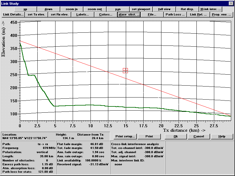
Figure 1 shows a representation of a radio wave propagating from a mountaintop transmitter (on the left) to a receiver location in the open (on the right). Although the signal arriving at the receiver will include some reflections from the terrain, the dominant signal is the one that arrives directly from the transmitter. Figure 2 shows the same radio path but with a tree placed in front of the receiver. Because of the tree, the signal is some 9 dB weaker than it is without the tree at a frequency of 870 MHz (a frequency in the cellular phone band). This is the effect of groundcover on signal propagation.
Figure 1. Radio propagation path without obstructions (open land cover).
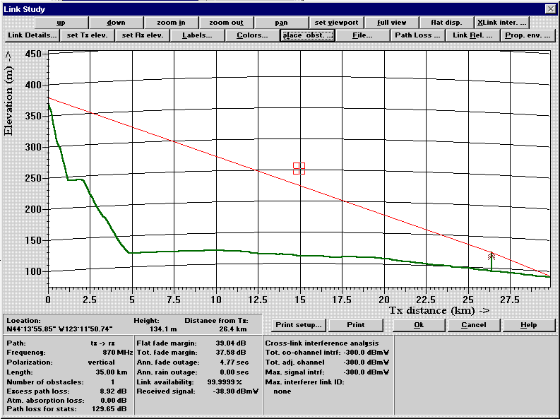
Figure 2. Radio propagation with tree obstructions (forest land cover).
When buildings are considered in three dimensions, as shown in Figure 3, the situation becomes considerably more complicated. The radio signal from the transmitter arrives at the receiver by diffracting and reflecting from the four buildings shown in this figure. Because the signals arrive at the receiver via a number of radio paths, the signal at the receiver is often described as a "multipath signal." A multipath signal can have a significant impact on the signal quality or integrity of data which is sent because several versions of the same signal are arriving at the receiver at different times.
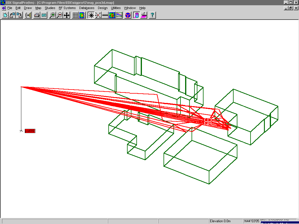
Figure 3. 3D radio wave propagation over buildings in an urban environment.
As the propagation environment becomes more complex, it is difficult for the propagation model to account for all of these possible radio paths. One approach known as ray-tracing is currently the most viable model for such conditions [2],[3]. With ray-tracing, complex environments such as entire downtown areas can be considered as shown in Figure 4. The signal strength as the mobile user (a cellular phone in a car) moves along a route can also be calculated as shown in Figure 5. Note how the peak in the signal strength occurs due east of the transmitter, where the path from the transmitter to the mobile is straight down a street with no intervening obstructions (approximately halfway through the route).
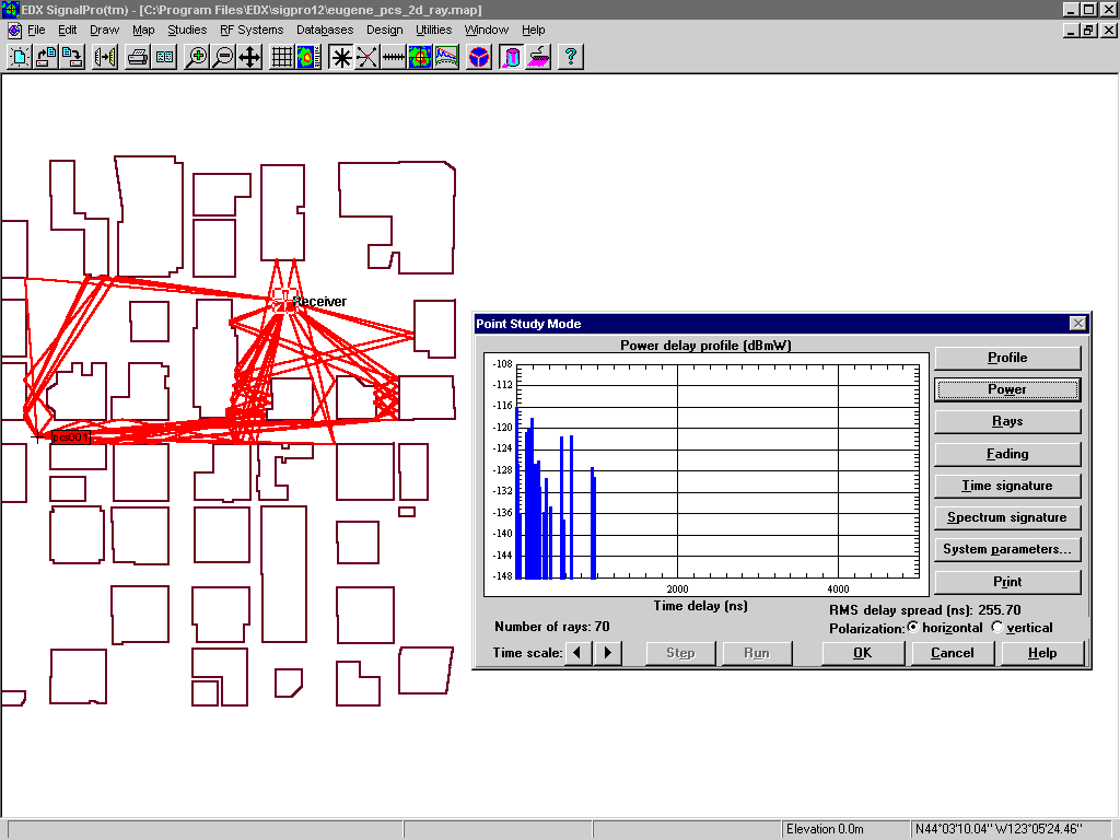
Figure 4. Rays showing multipath signal trajectories in an urban environment.
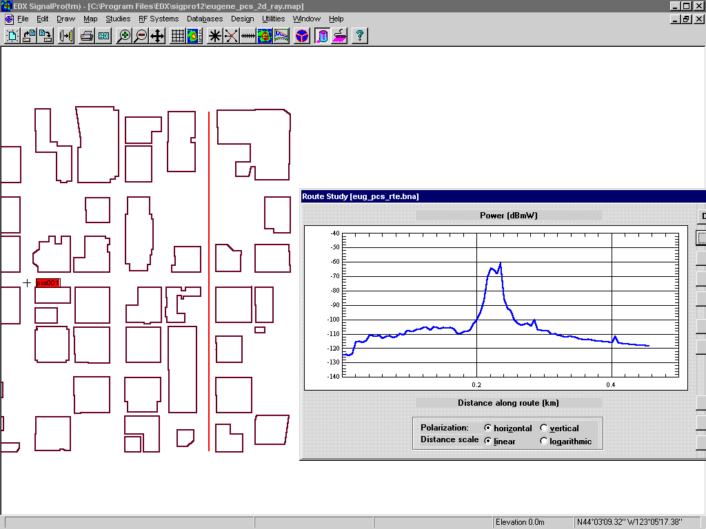
Figure 5. Signal strength along a route through an urban environment.
As explained above, in complex environments the signal arrives at the receiver via multiple paths and at different times. A quantity often used to described multipath is "RMS delay spread". Figure 6 shows a plot of the predicted RMS (route mean square) delay spread at a mobile unit moving along the same urban route as shown in Figure 5. Notice that the least amount of delay occurs at the point where signal strength is strongest in Figure 5.
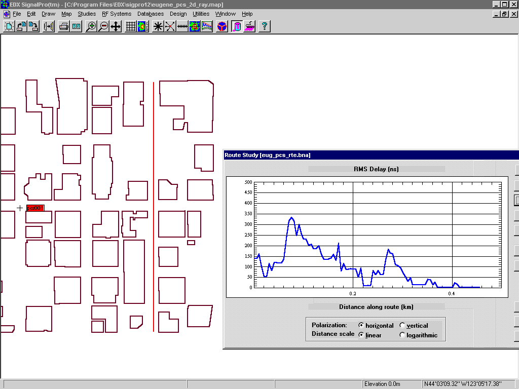
Figure 6. RMS delay spread (multipath) along a route through an urban environment.
A ray-tracing propagation model has been used here to investigate the impact that different types of groundcover have on radio waves. However, for most systems like normal cellular or PCS, the detailed analysis possible with ray-tracing is computationally too intensive for area-wide use. Moreover, acquiring databases describing the location and characteristics of every tree or building is generally not practical. Therefore, to simplify the problem of accounting for groundcover data in propagation prediction, we seek to broadly classify the data in some way. For example, instead of considering every tree in a forest, a wider area would be classified as "forest" and any receiver located within that area would experience an additional signal strength loss of 9 dB at 870 MHz. A similar approach could be used to find the loss at other frequencies. If signal loss data were also available for different types of forest, e.g. "evergreen" versus "deciduous," or "tall" trees versus "short" trees, then multiple groundcover classifications for forests would be appropriate.
Many land use classification schemes provide for a large number of categories that may be appropriate for land use planning or zoning [4]. However, as demonstrated above, for the purpose of wireless system design, unless calculations or measurements are available that demonstrate a statistically significant difference between categories in terms of their relative impact on radio signals, having the additional categories does not provide more accurate signal predictions.
As mentioned above, the task of classifying built-up areas with structures has been somewhat arbitrary or even irrelevant in terms of how such classifications can be used for wireless system design. Attempts have been made to categorize urban areas in order to more accurately predict signal attenuation [5]. As the discussion in Section 2 illustrated, the height, extent, and location of buildings are the factors which primarily govern the impact on radio signals. Different classification types such as "industrial" and "commercial" may be useful in urban planning, but if both indicate relatively low buildings of broad extent, then the distinction is unimportant for wireless engineering - both will affect the signal in similar ways.
In an effort to quantify the attributes of structure data in a way which is meaningful to wireless design, we undertook a study of structures commonly found in metropolitan areas in the U.S.. These included a residential area with single and two-story dwellings on average size lots, buildings in the downtown area of a modest-size city (Eugene, Oregon), and buildings throughout Manhattan which can safely be regarded as one of the most intensely urban areas in the world. A portion of the Manhattan database used in this study is shown in Figure 7. Since the downtown area of Eugene (see Figure 4), where structure information was available, constituted a 400x400 meter square, we divided the Manhattan data into equivalent size blocks for comparison. Within each 400x400 meter block a uniform 10 meter sampling grid was established, and the height of the data was determined at each 10 meter point (1600 points per block). Building tops, shoulders, and street level points were included in the calculation of block height.
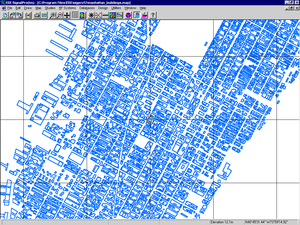
Figure 7. Portion of EDX's Manhattan database used for urban density studies.
Using this data set of 1600 sample points for each block, several statistics were derived for each block, including maximum height, average height, and the standard deviation of the heights. The statistics were evaluated to determine which might be the most useful measure of the intensity of urbanization in a given block. The maximum height was easily biased - the World Trade Center is located in an area of otherwise relatively low buildings. The standard deviation was an interesting quantity but again was distorted by singular tall structures. The average building height turned out to be the best indicator of urban intensity since it properly reflected blocks with broadly extended low-rise structures (like shopping malls) and was not unduly distorted by singular structures situated in an otherwise open area.
The average building height for typical residential areas was 1.2 meters. The average building height for the Eugene downtown was 5.6 meters. The distribution of the average building heights for the 196 blocks evaluated in Manhattan is shown in Figure 8.
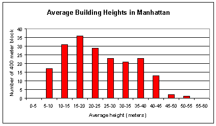
Figure 8. Distribution of average building heights for 400-meter blocks in Manhattan.
From this quantitative information, some general categories of urban density can be developed as shown in Table 1.
Table 1. Derived Classification Types |
|
| Classification | Average block height |
| Residential | 2 meters |
| Low density urban | 5 - 10 meters |
| Moderate density urban | 10 -25 meters |
| High density urban | 25 meters |
Using these values, and a rational blocking such as that used here, it is a straightforward task to categorize any urban area in this way if the appropriate building height and vector outline data is available.
A future step is to develop signal loss values for each of these categories as a function of transmitter frequency.
The core of any wireless communication system is the network of towers, transmitters and antennas that convert information to radio signals that can be received and understood by the user. The network must be configured so that enough channels are allocated to handle the demand. Considerations in system design are: locating transmitters to provide adequate signal levels throughout the service area, judging where system capacity may be insufficient (or under-utilized), and in the case of cellular systems, gauging how the system may have to evolve to accommodate changing call traffic patterns.
These dynamic call traffic patterns refer to time and location. People are placing calls at random times throughout the day, and because callers are mobile, they may be located anywhere in the system service area. For example, during morning and evening rush hour, call traffic density for cellular phones is highest along transportation routes. Large, temporary gatherings of users--convention centers, concert halls, sporting events--must be considered. During work hours call traffic is highest in the city centers. But as wireless cable, wireless fixed telephone (the next generation of telephone service which does not need a land line) and data transmission (fax and computer modem) services are deployed, wireless traffic in residential areas will increase dramatically.
To determine the number of radio channels that must be provided by each cell site in order to handle the call traffic (or call density), it is necessary to somehow establish a geographical distribution for the calls relative to the cell sites. Planners have traditionally accounted for traffic in one of four ways:
1. Assume geographically uniform traffic distribution (in the absence of other data).
2. Use a standard demographic database and assume that more capacity is needed where population density is highest.
3. Use a road database as a guide for defining traffic and the geographic location of where calls are originated.
4. Use actual call traffic patterns, which vary by location and time of day. This is the best indicator of traffic demand, but difficult to obtain because this information is generated in the switches of existing cellular systems whose operators may not be willing to release this data.
A fifth alternative for predicting where usage is highest throughout the day is to use up-to-date land use classifications. By seeing where transportation, urban, dense urban and residential categories are located and correlating this information with call density trends, a picture of call traffic will emerge.
Land use data is useful for wireless systems other than cellular. Paging, which has high usage in urban areas, requires higher signal strength due to attenuation caused by building walls. Knowing the location of urban and dense urban areas will help target demand for service. Television and radio broadcasting, which mainly targets residential markets, would benefit from knowing where new residential areas will be located-a function of land use planning classifications.
To illustrate the role of groundcover data in wireless system design, two signal studies were performed to show the effect of groundcover on signal strength. The area for the signal study is Eugene, Oregon, which is at the southern end of the Willamette Valley.
Figure 9 shows the terrain elevation for the study area. Near the city center elevation is approximately 120 meters. Eugene is surrounded on the west, south and east by hills with elevations as high as 850 meters. Major roads of the area are also shown.
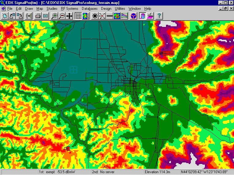
Figure 9. Terrain elevations and major roads in the Eugene area.
The first signal study was performed using only terrain as a factor in determining signal strength (see Figure 10). The transmitter is located in Coburg Hills, at an elevation of 570 meters. This transmitting station uses a directional antenna which directs most of its power to the southwest over Eugene (a pointing azimuth of 225 degrees). The receive antenna is a low gain omni-directional antenna like those used in cellular phone handsets or as mobile antennas on fleet or public safety vehicles. By systematically positioning the receive antenna at a uniform grid of locations throughout the service area around the transmitting antenna and calculating signal strength at each location, a map grid is developed in which the different signal level ranges are depicted by different colors.
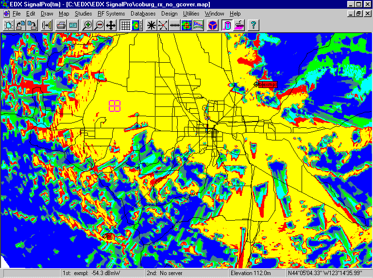
Figure 10. Signal strength using terrain only.
Notice that the signal patterns are strongly affected by the terrain. The strongest signals are shown in yellow and occur where there are no terrain obstructions between the transmitter and receiver. The weakest signals are shown in dark green and dark blue. They generally occur due to shadowing--the signal is greatly weakened due to an obstruction, such as a hill. It has been diffracted over the top and around the sides. In the shadow cast by the hill the strength of the signal is diminished. The southwest portion of the signal study, which is mostly dark blue, illustrates this point.
Figure 11 shows land use/land cover for the study area. Forest land (bright green) covers the majority of the area surrounding Eugene. Agricultural land (dark green) covers a large portion of the Willamette Valley. The urban, commercial and industrial uses in the center of Eugene are shown in red and pink. Residential is shown in yellow.
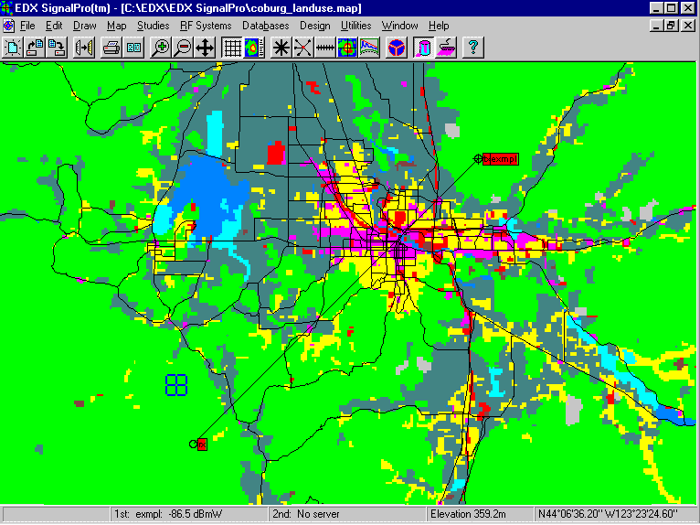
Figure 11. Land use in the Eugene area.
Figure 12 shows a signal study that takes into account signal attenuation due to groundcover as well as terrain. Notice that the signal pattern is dramatically different from the one shown in Figure 10. The area that has the largest reduction in signal strength is the urban area-large portions of the yellow have become red. This is due to reflection, scattering and absorption by the urban and residential structures. The shadowing patterns (greens and blues) caused by hills are basically the same. Also, along the main roads of Eugene, which are flanked by commercial and industrial usage, the signal has weakened. In the southeast and southwest quadrants of the study area where the groundcover is forest land, the signal has weakened due to scattering of the radio waves by leaves and branches.
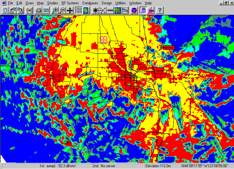
Figure 12. Signal strength using both terrain and groundcover data.
From these examples it is clear that groundcover data plays an important role in wireless system design. Adding this information can provide an important refinement to a signal study by taking into account a more accurate and realistic characterization of the service area where the wireless system will be used.
Land use/land cover (groundcover) data can have many uses in wireless system design. The most significant applications are in refining signal level predictions to take into account local clutter attenuation effects, and in projecting demands for wireless service. The latter is becoming increasingly important as new types of fixed, broadband wireless services (video, voice and data) such as MDS, LMDS and wireless local loop are deployed alongside existing mobile cellular and PCS services.
The use of groundcover data can offer clear advantages for signal level predictions. However, the quality of the information regarding groundcover categories and the signal attenuation levels for various frequencies in each category will determine the ultimate value of land use data. Given the current level of engineering information about such signal attenuation, typically only five or six categories of groundcover information can be effectively used to provide statistically significant distinctions in signal level attenuation prediction. Obtaining groundcover data with a large variety of groundcover classifications may represent an unnecessary expense.
It was also shown that a detailed, incisive propagation modeling technique known as ray-tracing provides a sound physical basis for investigating the degree of signal attenuation for different types of groundcover environments.
A quantitative approach to classifying the relative density of urban data for signal propagation purposes was also presented. Using the block data derived from EDX's building databases, it was found that average block elevation based on a uniform systematic sampling provides a good indicator of relative urban density. By considering a broad sample of urban densities, a worthwhile next research step would be to apply the ray-tracing model to these blocks to arrive at associated signal attenuation values as a function of frequency. Such values could then be directly applied to the simplified signal prediction process.
Land use data can also play an important role in projecting demand for wireless services. With an increasing trend toward fixed, broadband wireless services, land use data used in conjunction with building height and location data can provide the wireless system designer with a valuable understanding of where service will be required and at what capacity. In this regard, land use data which is as up-to-date as possible is critical. Zoning data that shows a community's plans for future growth can also be effectively applied in the design process.
Finally, some real examples of wireless system coverage prediction were presented with and without groundcover data. Through the use of modern wireless system engineering software, such as those available from EDX, the designer can not only prepare accurate predictions of service and interference areas, but can also rapidly evaluate a wide variety of strategies to arrive at a system configuration that best meets the service provider's objectives at the least cost.
Jody L. Kirtner, M.A., GIS Specialist
Harry R. Anderson, Ph.D., P.E., President
EDX Engineering, Inc.
P.O. Box 1547, Eugene, OR 97405
Contact: jlk@edx.com
tel: 541-345-0019 fax: 541-345-8145